정읍,내장산,국립공원,대설,Jeongeup, Naejangsan, national park, heavy snow,1 1
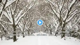
내장산 전북특별자치도 정읍시 내장동과 순창군 복흥면의 경계에 있는 산. 영은산(靈隱山)이라고도 한다. 높이 763.5 m이다. 노령산맥의 중간 부분에 있으며 신선봉(神仙峰:763.5 m)을 중심으로 연지봉(蓮池峰:720m)·까치봉(680m)·장군봉(670m)·연자봉(660m)·망해봉(640m)·불출봉(610m)·서래봉(580m)·월령봉(420m) 등이 동쪽으로 열린 말발굽 모양으로 둘러서 있다. 주요 지질은 백악기 말의 화산암류이고 주요 암석은 안산암으로 절리(節理)가 나타나 산꼭대기에는 가파른 절벽, 산 경사면에는 애추(崖錐)가 발달되어 있다. 식물은 참나무류·단풍나무류·층층나무류 등의 낙엽활엽수림이 주종을 이루고 능선에는 비자나무 등의 침엽수림이 나타난다. 신선봉·장군봉 등에 있는 굴거리나무 군락은 천연기념물 제91호로 지정되었다. 가을철 단풍이 아름다워 옛날부터 조선 8경의 하나로 꼽혔다. 백제 때 영은조사가 세운 내장사와 임진왜란 때 승병들이 쌓았다는 동구리 골짜기의 내장산성이 있으며 금선폭포·용수폭포·신선문·기름바위 등도 잘 알려져 있다. 등산로는 능선 일주 코스와 백양사까지의 도보 코스가 주로 이용된다. 1971년 서쪽의 입암산(笠巖山:654m)과 남쪽 백양사 지구를 합한 총면적 75.8㎢를 국립공원으로 지정하여 보호, 관리하고 있다. Naejangsan A mountain on the border between Naejang-dong, Jeongeup-si, Jeollabuk-do and Bokheung-myeon, Sunchang-gun. It is also called Yeongeunsan (靈隱山). It is 763.5 m high. It is located in the middle of the Noryeong Mountain Range, and around Sinseonbong (神仙峰: 763.5 m), Yeonjibong (蓮池峰: 720 m), Kkachibong (680 m), Janggunbong (670 m), Yeonjabong (660 m), Manghaebong (640 m), Bulchulbong (610 m), Seoraebong (580 m), and Wolyeongbong (420 m) are surrounded in a horseshoe shape to the east. The main geology is volcanic rocks from the Late Cretaceous Period, and the main rock is andesite, which shows jointing, and there are steep cliffs at the top of the mountain and ridges on the slopes of the mountain. The vegetation is mainly comprised of deciduous broad-leaved forests such as oak, maple, and dogwood, and coniferous forests such as zelkova appear on the ridges. The grove of ginkgo trees on Sinsunbong and Janggunbong peaks has been designated as Natural Monument No. 91. The beautiful autumn foliage has long been considered one of the eight scenic views of Joseon. There is Naejangsa Temple, built by Yeongeunjosa during the Baekje period, and Naejangsanseong Fortress in Dongguri Valley, which is said to have been built by monk soldiers during the Imjin War. Geumseon Falls, Yongsu Falls, Sinseonmun Gate, and Gireumbawi Rock are also well-known. The hiking trails are mainly used as a ridge course and a walking course to Baekyangsa Temple. In 1971, a total area of 75.8㎢, including Ipamsan Mountain (笠巖山: 654m) to the west and the Baekyangsa Temple area to the south, was designated as a national park and is being protected and managed. 이 콘텐츠는 저작권이 있습니다. This content is copyrighted. https://creator-kr.pixtastock.com/@pr...

