![Create .kml or .kmz file in Google Earth and Convert to Shapefile [Part 1]](https://krtube.net/image/94l9Hm4RqkA.webp)
Create .kml or .kmz file in Google Earth and Convert to Shapefile [Part 1]
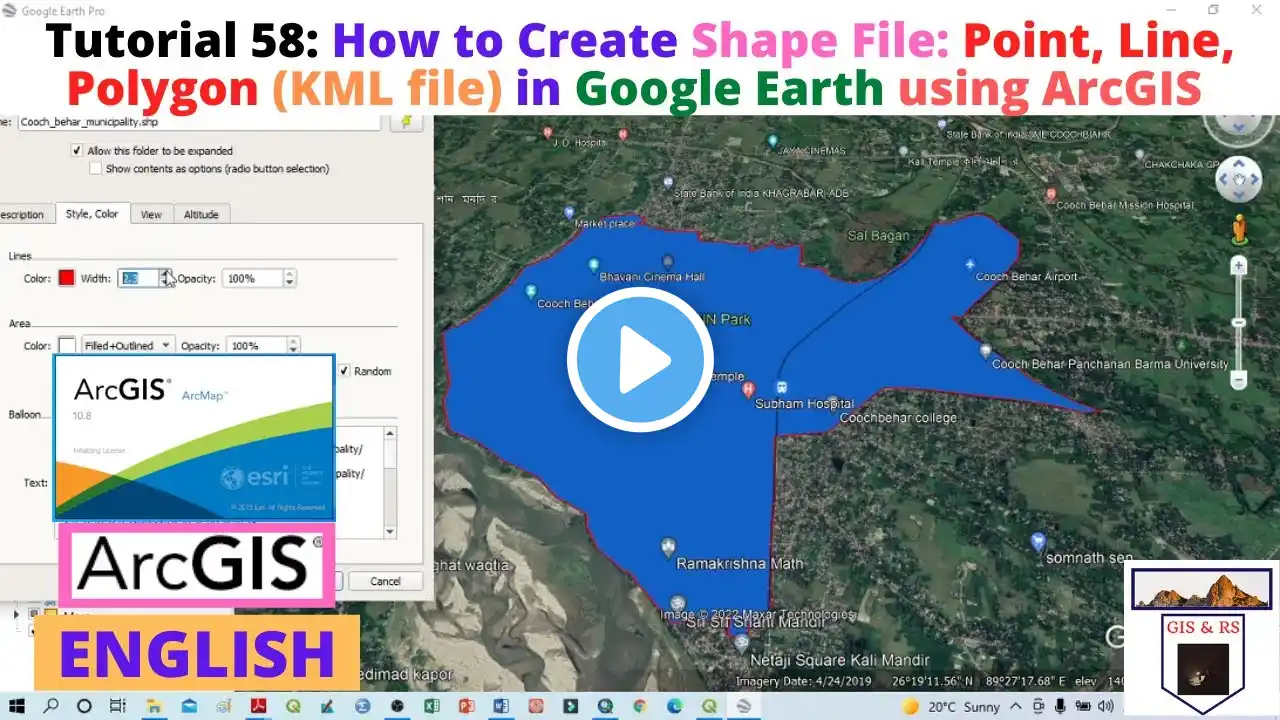
This video explain how to create .kml file from shapfile using ArcGIS and creation of path, placemark and polygon in Google Earth Sub for more. Thank you!! You can find more video that i create below: 1.How to divide land into proportional plots by using Parcel Farbric Tool in ArcMap - ||speak Khmer|| • How to divide land into proportional ... 2.How to mosaic Raster Image in ArcGIS |ArcMap10.8| • How to mosaic Raster Image in ArcGIS ... 3.Download High resolution image from Google Satellite by by Universal Map downloader • How to download very high-resolution ... 4. how to download High Resolution image from Google Satellite • how to download High Resolution image... 5. Create a Simple Map in ArcMap [Detail tutorial] - [Speak Khmer] • Create a Simple Map in ArcMap [Detail... 6.Create Map in ArcGIS Pro 2.6 - ||Speak Khmer|| - [Khmer GIS Academy] • How to Create Map in ArcGIS Pro 2.6 -... 7. Create Simple Land Plot from Survey Data in ArcMap - [Speak Khmer] - Khmer GIS Academy • Create Simple Land Plot from Survey D... 8. Composite Band of LandSat image and Mosaic Raster Data using Model Builder • Composite Band of LandSat image and M... 9. Create Land Cover type using Google Earth Image • Video 10. Georeferencing Google Earth Image and Digitization in ArcGIS • Georeferencing Google Earth Image and... 11. Join and Relate, tool for attribute table in ArcGIS • Join and Relate | How to join and rel... 12. Use Model builder to do more IDW process • How to use Model builder to iterate m... 13. Interpolation - find missing data using IDW tool in ArcGIS [Speak Khmer] - Khmer GIS Academy • How to find missing rainfall data usi... 14. Create Contour line using Elevation Data from Google Earth [Speak Khmer] • How to create Contour line using Elev... 15. Get Elevation data from Google Earth [Part 1] - [Speak Khmer] - Khmer GIS Academy • How to derive elevation data from Goo... 16. Convert kml or kmz (google earth pro) to Shapefile using ArcGIS (Speak Khmer) - Khmer GIS Academy • How to convert kml or kmz (google ear... 17. Using ArcGIS and Google Earth - Create .kml or .kmz file (Speak khmer) - Khmer GIS Academy [Part 1] • Create .kml or .kmz file in Google Ea... 18. Create Point Shapefile derived from Google Map in ArcGIS without using Excel (Speak Khmer) • How to Create Point Shapefile from Go... 19. Changing Projected Coordinate System in ArcGIS [Speak Khmer] - Khmer GIS Academy • How to change Projected Coordinate Sy... 20. Shapefile projection in ArcGIS [Speak Khmer] - Khmer GIS Academy • How to project shapefile in ArcGIS [S... 21. Create Topology for Shapefile - check the error of the shapefile [Speak Khmer] - Khmer GIS Academy • Create Topology for Shapefile - check... 22. Create a Sample Map in ArcGIS [Part 2] - (Speak Khmer) - Khmer GIS Academy • Create a Sample Map in ArcGIS [Part 2... 23. Create a Sample Map in ArcGIS [Part 1] - (Speak Khmer) - Khmer GIS Academy • How to create a Map in ArcGIS [Part 1... 24. ArcGIS - Apply Geoprocessing Clipping Tool to Model Builder [Speak Khmer] - Khmer GIS Academy • ArcGIS - Apply Geoprocessing Clipping... 25. ArcToolbox - Extract Toolset explanation and practice [Speak Khmer] - Khmer GIS Academy • How to Split/Seperate the Shapefile t... 26. Geoprocessing Tool - Clip and Merge in ArcGIS [Speak Khmer] - Khmer GIS Academy • How to Clip and Merge Shapefile in Ar... 27. Understand about the Attribute Table of a Shapefile [Speak Khmer] - Khmer GIS Academy • Understand about the Attribute Table ...