Land Use and Land Cover Accuracy Assessment Using ArcGIS (አማርኛ ቱቶር)
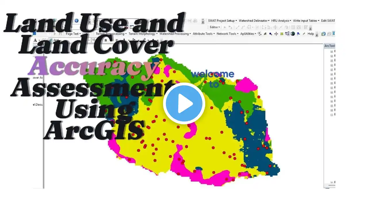
🌍 Land Use and Land Cover Accuracy Assessment Using ArcGIS 🛰️ Are you looking for a comprehensive guide to conducting land use and land cover (LULC) accuracy assessments using ArcGIS? This video is packed with expert insights, practical demonstrations, and step-by-step instructions to help you analyze spatial data effectively. Whether you're a GIS professional, remote sensing specialist, or a student exploring geospatial analysis, this tutorial is designed for you! 🚀 What You'll Learn in This Video: 1️⃣ Introduction to Land Use and Land Cover Analysis: Understand the key concepts of LULC mapping, its importance, and applications in urban planning, environmental monitoring, and natural resource management. 2️⃣ Accuracy Assessment Basics: Learn the importance of evaluating the accuracy of LULC classifications for ensuring data reliability in GIS projects. 3️⃣ ArcGIS Workflow: Dive into a step-by-step workflow for performing accuracy assessments using ArcGIS . 4️⃣ Confusion Matrix and Kappa Statistics: Get insights into creating a confusion matrix, calculating producer's accuracy, user's accuracy, and overall accuracy, along with understanding kappa coefficient. 5️⃣ Real-World Example: Follow a practical example that demonstrates accuracy assessment on real-world data. 💡 Why Watch This Video? 🔹 This video simplifies complex GIS concepts into easy-to-understand steps, making it perfect for beginners and advanced users alike. 🔹 Discover tips for improving LULC mapping accuracy and interpreting results effectively. 🔹 Enhance your proficiency with ArcGIS , a leading tool in geospatial data analysis. 🔑 Keywords Covered: Land Use and Land Cover (LULC) Accuracy Assessment in GIS Remote Sensing and LULC Mapping GIS Workflow for Accuracy Analysis Confusion Matrix in GIS Kappa Statistics for GIS Accuracy Spatial Data Analysis with ArcGIS LULC Mapping Techniques 🌟 Who Should Watch This Video? This video is ideal for: ✔️ GIS Analysts looking to improve accuracy in their LULC projects. ✔️ Remote Sensing Professionals working on land classification and environmental studies. ✔️ Students and Researchers seeking to understand the role of accuracy assessment in geospatial studies. ✔️ Urban Planners and Environmental Scientists using LULC data for decision-making. 💬 Join the Conversation! Have questions about accuracy assessment in ArcGIS? Drop your queries in the comments section below, and we’ll address them in upcoming videos! Don’t forget to share your experience and thoughts on this tutorial. 👍 Support the Channel! If you found this video helpful, give it a thumbs up, subscribe for more GIS and remote sensing content, and turn on the notification bell so you never miss an update!